Sector(s)
Team Members
Visit the site
Visit the siteOrganizations Involved
Community contributions
Custom Modules:
Shape to Leaflet Widget: Developed for integrating geospatial data into maps, shared with the community.
Advanced Search Algorithm: Created a 10-factor relevancy scoring system for enhanced search, contributed to the community.
Patches:
Improved Media Library and Responsive Images modules, enhancing stability and functionality.
Documentation:
Provided guides for custom modules and integration processes, aiding other developers.
Themes and UI Enhancements:
Developed a custom theme for rich media content and geospatial data, shared with the community.
Geospatial Tools:
Enhanced tools for managing geoJSON files and interactive maps, contributing to existing modules.
Social and Interactive Features:
Implemented the "Bavaria Before/After" widget for user participation, shared for other projects.
New Community Members:
Encouraged team participation in Drupal forums and events, adding new contributors.
The Bavarian State Ministry for the Environment and Consumer Protection initiated this project with a compelling vision - to empower app users to connect with nature like never before.
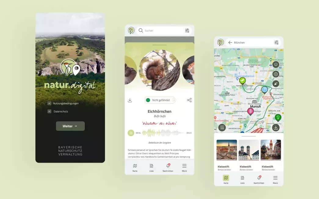
We helped them pave the way for this groundbreaking project, which aims to revolutionise the way people interact with nature and promote sustainable practices for generations to come. The application helps to discover paths, plants and animals all over Bavaria. Entertaining expert knowledge for nature lovers and those who want to become one.
About the project
Client's needs:
The client (Bavarian State Ministry for the Environment and Consumer Protection) wanted iOS, Android and web applications with the same functionalities that:
- Can publically show the data collected over 3 years within the Bavarian region about animals, plants, habitats, POIs, and other geo content of great importance.
- Can present the data in both map view and list view.
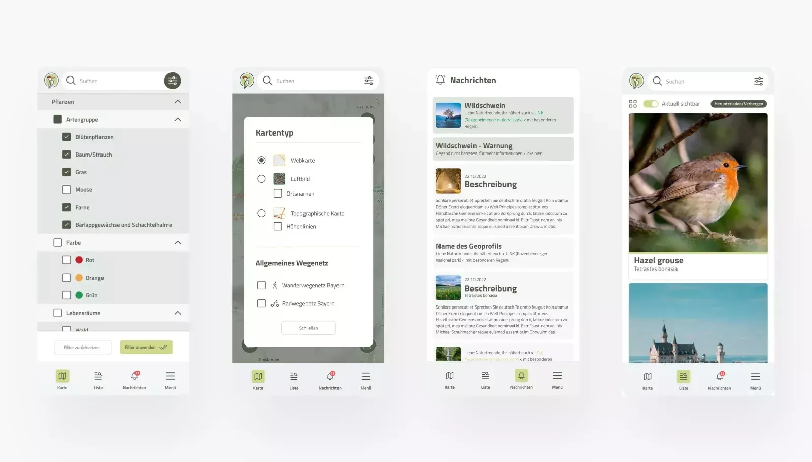
- Have an advanced search algorithm based on 10-factor relevancy scoring.
Also, their mobile application needed to have easy data search and smart filtering of the results.
The client wanted the capability to record, process, sort, and modify data over time. Additionally, they wanted users to be able to contribute images of landscapes and points of interest (POIs) within the 'Bavaria Before/After' comparison widget.
Solutions
Collecting Data: In the initial phase of the project, we focused on upgrading and maintaining the Drupal CMS responsible for managing data related to the natural world and geographical information. We implemented a series of improvements to streamline data entry and adjustment for content editors. One of our most significant tasks was developing importers for data from various government sources.
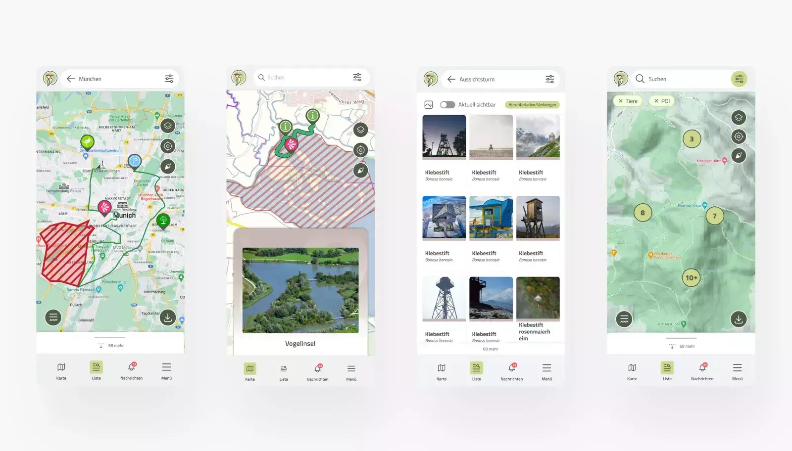
Geofencing: The application's primary purpose is to be used in natural environments, such as forests and mountains. However, some of these areas have restricted access, either permanently or seasonally. The application will notify users when they are near a restricted area, providing information about why access is limited and why it's essential to adhere to these restrictions.
Social Element: We encourage user participation in growing the application's content through a section called ""Bavaria Before/After."" In this section, our editors have compiled historical images of rivers, mountains, forests, and landscapes. Users have the opportunity to upload current images of the same locations and engage with a comparison widget. This interactive feature allows users to visualize and compare changes over time.
Additional Features: Users can access biking and hiking routes, as well as additional city information. The data is presented and organized using the Leaflet function, with various types of points represented as individual pins.
Lexicon (List) Function: The map displays geographical content, including routes, POIs, trails, animals, birds, mushrooms, and habitats in a list format for easy reference.
Advanced Search: The app features an advanced search function that provides information on various topics, such as bear sightings, dietary habits, predators, mating seasons, endangerment status, and more.
Media Integration: Rich media content, including sound, videos, and images, enhances the user experience.
Design and Database Architecture: We have designed the architecture for iOS, Android, and web applications to showcase collected data to the public.
Map View: The application offers three types of maps presented as layers: vector, satellite, and spatial. These revisions clarify the text and improve overall readability while maintaining the original content's intent.
The results
An intuitive and user-friendly interface of Nature Digital’s app. With seamless navigation and clear visual cues, users can easily grasp its functionalities right from their first interaction.
Why Drupal was chosen
The institution already started filling the content inside Drupal CMS, so we just inheridated project from previous agency and continued development with new functionalities and improvements. Drupal was a solic choice because of nicely organized content types which are serving both internal CMS and applications. More than 30 people are working constantly on filling content part based on permissions and roles.
Technical Specifications
Drupal version:
Key modules/theme/distribution used:
The CMS is heavaly depending on easy content moderation. Client is filing the text, images, videos, and also geospatial data, based on geo JSON files. If you are content editor there is a map editor for every POI, Route or Area. The sistem notifies the approval personel about new content which must be checked before the public releases.
We are using a lot of image styles in a different shapes and various sizezs (more than 20).
The Drupal is perfectly cabable of fullfinling every need from the client. Regarding new fields, exports in Excel, imports, reports, views, we are even feeding the separate database used for applications.