Sector(s)
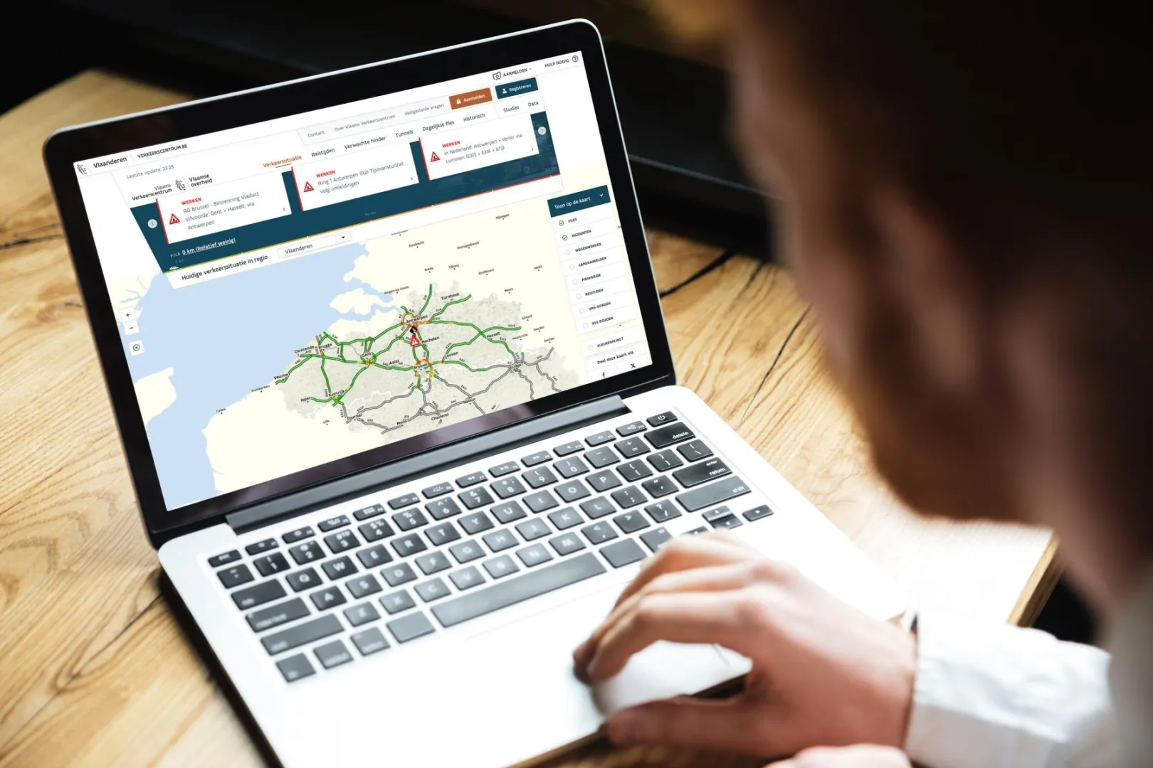
The Flemish Traffic Control Center (Vlaams Verkeerscentrum) brings together all tasks related to operational traffic and tunnel management on the main roads in Flanders. As a 24/7 service for reporting malfunctions, defects, and breakdowns of technical installations, the Traffic Center also supports the technical management of the road authority. It is a department of the Agency for Roads and Traffic (Agentschap Wegen en Verkeer).
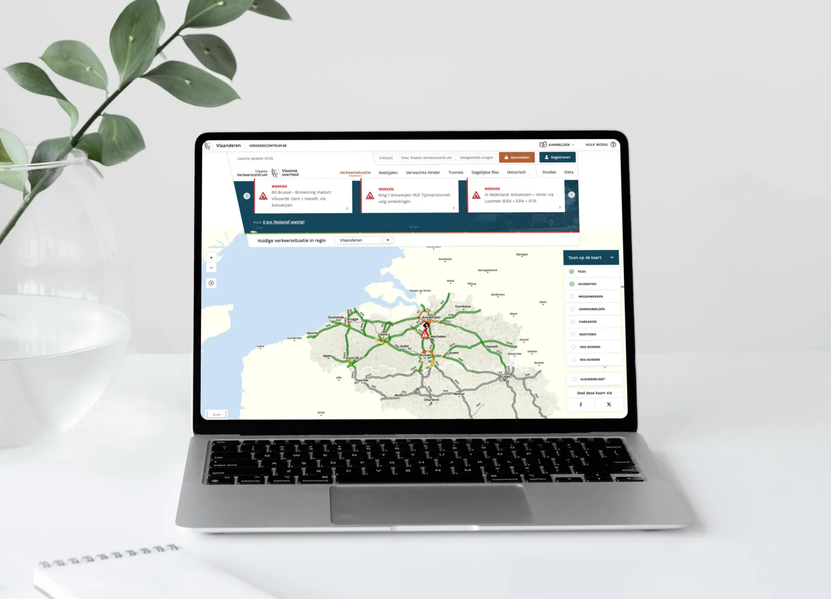
The challenge was to develop a new website with an integrated map. The combination of a powerful yet flexible framework and a map solution that meets the highest standards ensures that the new site becomes the gateway for current and historical mobility information in Flanders.
About the project
To address the client’s challenge, we designed and developed a scalable, high-performance web platform based on Drupal, integrated with a real-time and interactive map interface tailored to mobility data in Flanders.
Technologies Used
- Drupal 8 → 9 → 10: The entire platform was developed in Drupal, with progressive upgrades to ensure long-term maintainability and access to modern features.
- Randstad Digital Builder: Enables flexible page-building through reusable components like WYSIWYG editors, carousels, and image grids.
- Custom Map: Built by an external partner using OpenLayers and AngularJS, embedded via a JavaScript widget.
- Traffic Data Integration:
- Real-time traffic and incident data from the Traffic Control Center (TCC).
- Open Data APIs for parking availability and traffic signs.
- HTML5 Location API: For user geolocation and improved map interaction.
Functional Description
Following a user-centered functional analysis, development focused on both usability for administrators and clarity for end users.
Key Features:
- A new web design, in line with the visual identity of the Flemish Government.
- A clear road map with information about travel times, incidents, the location of park & ride zones … Including the option to switch to a colorblind-friendly style.
- In addition to current traffic information, you can also get an indication of traffic congestion on a specific weekday and at a specific time.
- Drupal saves a snapshot every 15 minutes based on information from the Traffic Control Centre. This makes it possible to retrieve historical traffic data.
- You can calculate travel time between two junctions and view the situation for the Brussels and Antwerp ring roads.
- You’ll find news articles and live camera images, can read more about planned roadworks, and consult studies, datasets, and frequently asked questions.
- The website offers the possibility to register. This allows you to add a route you travel regularly. Afterwards, you can quickly and easily view the details of that route.
Performance & Architecture
- The site ingests live data every minute, but thanks to selective cache control, only relevant parts of the website bypass caching — ensuring high performance without impacting the user experience.
- Hosting architecture includes full failover redundancy: If a web or database server fails, a backup immediately takes over. This ensures zero downtime and high availability.
⸻
This solution combined robust backend technology (Drupal) with advanced geospatial integration, data visualization, and high availability infrastructure, making it a future-proof platform for mobility communication in Flanders.
Why Drupal was chosen
Drupal was selected because it has no vendor lock-in, is able to scale well to handle huge traffic spikes and is easy to integrate with other technologies.
Technical Specifications
Drupal version: